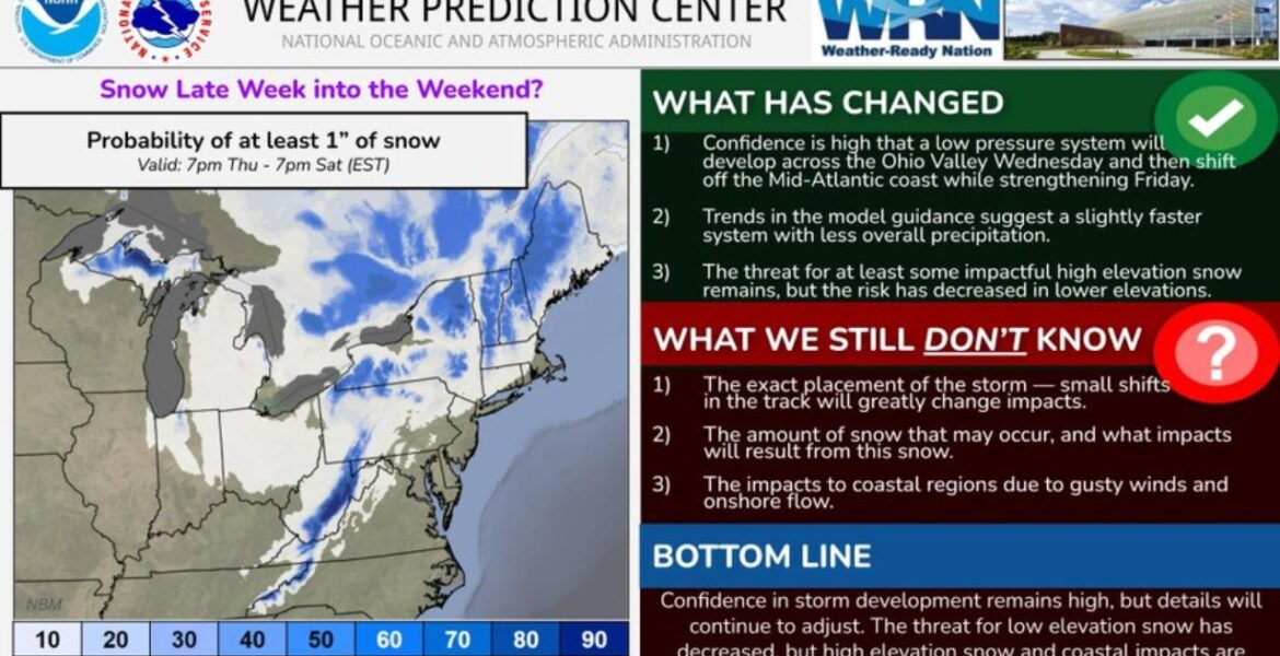
MID-ATLANTIC — A storm system is set to develop this week and could bring the first snow of the season to parts of the Northeast and Mid-Atlantic. Our team has high confidence that a low pressure system will form across the Ohio Valley on Wednesday November 11 and then strengthen off the Mid-Atlantic coast on Friday November 13. The best chance for at least 1 inch of snow is in the higher elevations, while lower areas now look less likely to see snow.
Key Numbers at a Glance
| Detail | Information |
|---|---|
| Storm forms | Across the Ohio Valley on Wednesday November 11 |
| Storm strengthens | Off the Mid-Atlantic coast on Friday November 13 |
| Snow window | 7:00 PM EST Thursday November 12 to 7:00 PM EST Saturday November 14 |
| Snow threshold | At least 1 inch |
| Highest snow chances | Higher elevations of the Appalachians and Northeast mountains |
| Low elevation snow risk | Decreased |
| Coastal threat | Gusty winds and onshore flow |
Where It Is Hitting
Our snow probability map shows where at least 1 inch of snow is most likely:
- West Virginia and western Maryland mountains show some of the better chances in the Mid-Atlantic.
- Pennsylvania’s higher terrain, including the central and northern mountains, is in line for possible snow.
- New York’s mountains, including upstate higher elevations, show increased chances.
- Vermont, New Hampshire and western Maine mountains could also pick up snow.
- Parts of northern Michigan and Wisconsin show lower chances farther west.
Cities in lower elevations and along the coast now look less likely to see accumulating snow.
When to Expect It
- Wednesday November 11: The low pressure system develops across the Ohio Valley.
- Thursday evening November 12: The snow window opens at 7:00 PM EST as colder air moves in.
- Friday November 13: The storm moves off the Mid-Atlantic coast and strengthens, bringing the best chance for mountain snow and gusty coastal winds.
- Saturday November 14: Snow chances wind down by 7:00 PM EST as the storm pulls away.
What Has Changed
Forecasts have shifted in a few important ways. The storm now looks slightly faster, with less overall precipitation than earlier forecasts showed. That has lowered the chance of snow in lower elevations. However, the threat for at least some impactful snow in the higher elevations remains.
What We Still Do Not Know
There are still important questions about this storm:
- The exact track remains uncertain, and small shifts could greatly change who gets snow.
- How much snow falls, and what impacts it causes, is still being worked out.
- How strong the coastal impacts will be from gusty winds and onshore flow is not yet clear.
Why This Is Happening
As the storm moves off the coast and strengthens, it will pull colder air in from the north. In the mountains, where temperatures are already cooler, that colder air can turn rain into snow. Along the coast, the strengthening storm will push winds off the ocean toward land, which can raise water levels and bring gusty conditions.
What This Means for You
People living or traveling in the mountains of West Virginia, Pennsylvania, New York and Vermont should be ready for possible snowy roads, especially on Friday. Coastal residents should prepare for gusty winds and possible minor coastal impacts. In lower elevations, most people can expect rain or a cold, wet day rather than snow.
How to Stay Safe
- Check road conditions before driving through mountain areas on Friday and Saturday.
- Prepare your car with an ice scraper, blankets and snacks.
- Secure outdoor items along the coast ahead of gusty winds.
- Allow extra travel time during the storm.
- Follow forecast updates, since the storm track could still shift.
- Keep weather alerts turned on for winter weather or coastal warnings.
Boxingessential.com will continue tracking the late week storm across West Virginia, Pennsylvania, New York and Vermont, along with coastal impacts in the Mid-Atlantic, and will provide updates as the storm track, snow chances and wind threats develop.
You may also like
Leave a Reply