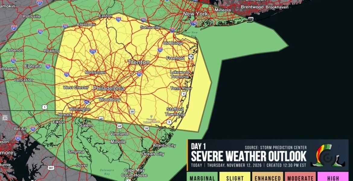
PHILADELPHIA, Pennsylvania — Parts of eastern Pennsylvania and central New Jersey were upgraded to a Slight Risk, Level 2 of 5, for severe weather on Thursday November 12. The outlook, created at 12:30 PM EST, warned that isolated supercells could form along a warm front during the afternoon. Severe hail was the main concern, with a tornado or two and damaging gusts also possible.
Upgraded to Level 2 by Midday Thursday
The upgrade came as forecasters saw conditions coming together faster than expected. A Level 2 Slight Risk means scattered severe storms are possible, a step above the lowest category. For the Philadelphia region in mid-November, that is a notable threat level.
Later that day, video captured a tornado dropping near Wilmington, Delaware, then touching down again east of the city as it moved toward New Jersey.
Philadelphia to the Jersey Shore Inside the Slight Risk
The Level 2 zone covered a large and heavily populated area:
- Philadelphia, Norristown, West Chester and Woodbury sat in the heart of the risk area.
- Allentown and Easton were included at the northern end.
- Trenton, Somerville, Old Bridge and Freehold in central New Jersey were inside the zone.
- Lakewood Township, Toms River and Stafford Township along the Jersey Shore were also included.
- Wilmington sat near the southwestern edge of the Slight Risk.
Millions of people live inside this zone, making it one of the most populated severe weather risk areas of the fall.
Marginal Risk From Lancaster to Long Island
A wider Level 1 Marginal Risk surrounded the main zone:
| Region | Cities in the Marginal Risk |
|---|---|
| Central Pennsylvania | Reading, Lancaster, Lebanon, Ephrata, Pottsville, Jim Thorpe |
| Delaware and Maryland | Newark, Elkton, Dover, Smyrna |
| South Jersey | Salem, Vineland, Millville, Atlantic City, Ocean City, Cape May Court House |
| New York area | New York City, Paterson, Mineola, Brentwood, Smithtown |
A Warm Front Became the Storm Trigger
The key player on Thursday was a warm front, the boundary where warmer, moist air pushes north into cooler air. Along this boundary, winds change direction and speed with height, which can help storms start to rotate. That made the warm front the most likely spot for supercells, the strongest type of thunderstorm.
This was the same strong storm system spinning near New York City that brought the season’s first snow to upstate New York later that night.
Why Hail Was the Top Concern
Supercells have powerful updrafts that can hold ice high in the storm long enough for hailstones to grow large. With cold air in the upper atmosphere this time of year, hail can form more easily. That is why severe hail was listed as the main threat, even ahead of tornadoes.
Large hail can dent cars, crack windshields and damage roofs in just a few minutes.
Tornado Threat Turned Real Near Wilmington
Forecasters warned that a tornado or two could form, and that is exactly what appeared to happen near Wilmington. Video showed one touchdown west of the city and a second, fully condensed funnel east of the city. Damage surveys will help confirm how strong it was and where it traveled.
Staying Ready for Fall Severe Weather
- Take Level 2 risks seriously, even in places where severe storms are less common.
- Keep alerts turned on during afternoon and evening storms.
- Park cars in garages when hail is the main threat.
- Know your safe place, such as a basement or interior room.
- Avoid filming storms near windows, since glass can break in strong winds.
Boxingessential.com will continue tracking severe storms and tornado reports across Pennsylvania, New Jersey and Delaware, including Philadelphia, Trenton and Wilmington, and will provide updates as damage surveys and storm reports develop.
You may also like
Leave a Reply