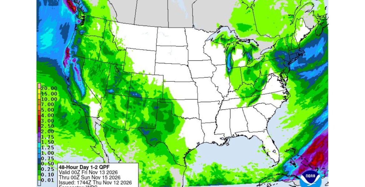
NORTHERN CALIFORNIA — A large atmospheric river made landfall on Thursday November 12, pushing heavy rain into Northern California and the Pacific Northwest. A second storm is lining up right behind it, bringing more rain to the West Coast and a good chance of snow in the Sierra Nevada. Our 48-hour rainfall map, covering Thursday evening through Saturday afternoon November 14, shows the wettest coastal mountains picking up 2 to 4 inches of rain.
First Atmospheric River Makes Landfall
An atmospheric river is a long, narrow stream of moisture flowing through the sky from the Pacific Ocean. When it hits land, the moisture is forced up and over the coastal mountains, where it falls as heavy rain or mountain snow. This one arrived right on schedule after our team flagged the West Coast for an active storm pattern earlier this week.
Where the Heaviest Rain Is Falling
The highest rainfall totals on the map line up along the coast and the mountains facing the ocean:
- The Olympic Peninsula in Washington shows the deepest colors, pointing to 3 to 4 inches in the wettest spots.
- The southern Oregon coast and far Northern California show another band of 2 to 3 inches or more.
- Coastal ranges and the Cascades across Washington and Oregon show widespread totals of 1 to 2 inches.
- Inland valleys in Oregon and Washington show lighter amounts, mostly under 1 inch.
A Second Storm Lines Up Behind It
The first storm is not the end of the wet weather. A second system is expected to bring more precipitation to the West Coast, following the same general path. Back-to-back storms like this give the ground little time to dry out between rounds.
That raises the chance of rising rivers, flooded roads and mudslides on steep slopes, especially in areas that already picked up heavy rain on Thursday.
Sierra Nevada Snow Returns
As the second storm moves in, colder air will help turn precipitation to snow in the Sierra Nevada. Mountain passes in California could become snow-covered, slowing travel and possibly requiring chains. For ski areas and water supplies, early mountain snow is welcome news.
Rain Reaches Well Beyond the Coast
The wet pattern stretches far inland on the map:
| Region | Expected Rain Through Saturday Afternoon |
|---|---|
| Olympic Peninsula, Washington | Up to 3 to 4 inches |
| Southern Oregon and Northern California coast | 2 to 3 inches or more |
| Cascades and coastal ranges | 1 to 2 inches |
| Idaho, Utah, Nevada | Mostly 0.10 to 0.50 inches |
| New Mexico, West Texas, Oklahoma | 0.25 to 1 inch in spots |
| Great Lakes and Northeast | 0.25 to 1 inch |
Rough Ocean Adds to the Mix
The heavy rain comes as a huge North Pacific storm sends giant waves toward the California coast this weekend. Surf could reach 30 to 35 feet near Eureka and sets up to 50 feet near San Francisco on Saturday. Combined with heavy rain, coastal areas face a rough few days.
Staying Safe Through Two Storms
- Never drive through flooded roads, especially at night when water depth is hard to judge.
- Watch for mudslides and falling rocks on mountain and coastal highways.
- Check pass conditions and carry chains before driving through the Sierra Nevada.
- Clear gutters and storm drains between storms.
- Stay away from the shoreline as giant surf arrives this weekend.
- Keep flashlights and chargers ready in case of power outages.
Boxingessential.com will continue tracking the atmospheric river and second storm across California, Oregon and Washington, including the Sierra Nevada and the Olympic Peninsula, and will provide updates as rainfall totals, mountain snow and flooding threats develop through the weekend.
You may also like
Leave a Reply