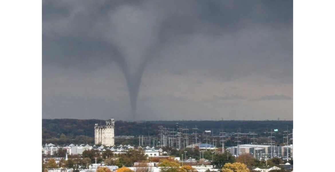
WILMINGTON, Delaware — Dramatic video captured a tornado dropping down just west of Wilmington this week, filmed from inside an office building overlooking the city. Moments later, the storm produced a second touchdown, this time with a fully condensed funnel stretching all the way to the ground east of Wilmington. The rotating storm was moving toward New Jersey, adding to a wild week of weather across the Mid-Atlantic.
Two Touchdowns From One Storm
According to the person who filmed it, the tornado first dropped just west of Wilmington. The storm then kept moving, and the tornado formed again east of the city, this time looking much stronger and more defined.
Storms that produce more than one tornado touchdown are often called cyclic, meaning the rotation weakens and then strengthens again as the storm moves along. Each new touchdown can bring a fresh threat to neighborhoods in its path.
What the Video and Photos Show
The images paint a striking picture against the city skyline:
- A dark gray sky hangs low over the area, with thick clouds stretching across the horizon.
- A narrow funnel reaches from the cloud base down to the ground, standing out clearly against the lighter sky.
- Rows of homes and trees with bright fall colors sit in the foreground.
- High-voltage power towers and a tall stone tower building line the view below the tornado.
- A shorter clip, about 39 seconds long, shows the first touchdown through rain-streaked glass.
What Fully Condensed Means
A fully condensed tornado is one where the funnel cloud is visible all the way from the storm cloud down to the ground. The funnel forms when air pressure drops inside the spinning column, causing moisture to condense into a cloud.
Not every tornado looks like this. Some only show a spinning cloud of dust or debris at the ground with no visible funnel above it. When a tornado is fully condensed, it is much easier to see and track, which is why this second touchdown stood out so clearly on camera.
Heading Toward New Jersey
After the second touchdown, the storm was moving east toward New Jersey, crossing the Delaware River area. Communities along the path in Delaware, Pennsylvania and New Jersey were urged to stay alert as the storm moved through.
Tornadoes can cross rivers and keep going, so water does not offer protection from a storm like this.
A Rare Sight for the Mid-Atlantic in November
Tornadoes are much less common in the Mid-Atlantic than in the Plains or the South, and they are even less common in November. When they do happen, they are often brief and form quickly inside fast-moving storms. That can leave very little time for people to take shelter.
This week has already brought unusual weather to the Northeast, including the first snow of the season in upstate New York and heavy rain along the coast.
Damage Still Being Checked
It is not yet clear whether the tornado caused damage or how strong it was. Weather officials usually survey the area after a tornado to look at damage and confirm its path and strength. That survey will help show exactly where the tornado touched down.
What to Do if a Tornado Is Near
- Move away from windows, even if you want to watch or film the storm.
- Go to the lowest floor and get into an interior room, closet or hallway.
- Cover your head and neck with your arms, a pillow or a helmet.
- Never try to outrun a tornado in a car through city traffic.
- Keep phone alerts on so you receive warnings right away.
- Stay away from downed power lines after the storm passes.
Boxingessential.com will continue tracking the Wilmington tornado across Delaware, Pennsylvania and New Jersey and will provide updates as damage surveys, storm reports and new warnings develop.
You may also like
Leave a Reply