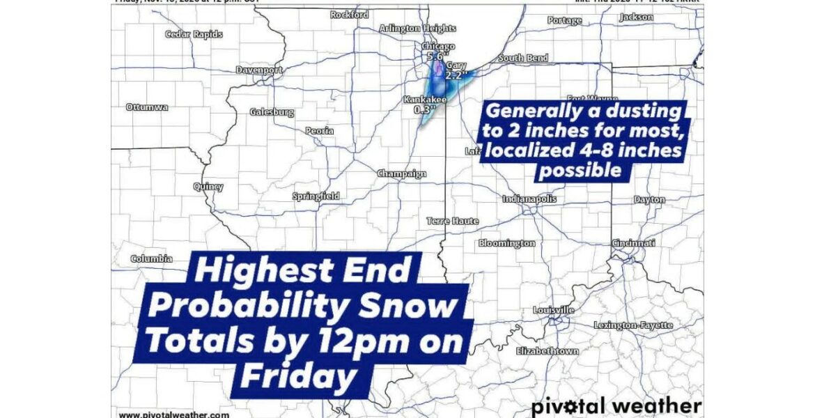
CHICAGO, Illinois — A narrow band of heavy snow has shifted west over the Chicago area, bringing a messy start to Friday November 13. Anyone from Chicago east to Valparaiso, Indiana could be in the path of the band from Thursday night through noon Friday. Most areas are looking at 1 to 3 inches, but a small pocket could pick up 3 to 6 inches, and possibly up to 8 inches by daybreak.
A Snow Band Shifts West Over the City
Earlier forecasts kept the heaviest snow a little farther east. The latest short-range forecast shifted the band west across the city of Chicago, putting more neighborhoods in line for accumulating snow. This forecast is the most aggressive one available, so it shows the high end of what could happen.
Narrow snow bands like this can be very hit or miss. One neighborhood can get several inches while another just a few miles away only sees a dusting.
How Much Snow Is Expected
| Area | Expected Snow |
|---|---|
| Most areas from Chicago to Valparaiso | 1 to 3 inches |
| Small pocket under the heaviest band | 3 to 6 inches |
| Highest possible totals | Up to 8 inches by daybreak Friday |
| Surrounding areas | A dusting to 2 inches |
Highest-End Forecast Shows 5.6 Inches in Chicago
Our high-end snow map for 12:00 PM CST Friday shows how the band could set up:
- Chicago shows the biggest total on the map at 5.6 inches.
- Gary, Indiana shows about 2.2 inches along the southern shore of Lake Michigan.
- Kankakee shows just 0.3 inches on the southern edge of the band.
- Areas outside the band, including Peoria, Champaign and Indianapolis, show little to no snow.
This map shows the highest-end outcome. Most places are likely to end up with less.
Why Grass Gets More Snow Than Roads
Ground temperatures are still fairly warm after a mild fall, so much of the snow will melt on contact with pavement at first. That means the highest totals will be measured on grassy and elevated surfaces, like lawns, car roofs and decks, rather than on roads and sidewalks.
When snow falls heavily enough, though, it can pile up faster than it melts. That is when roads can quickly turn white and slick.
Snow Packed Roads for the Morning Commute
Roads could become snow packed overnight and into Friday morning, especially under the heaviest part of the band. That could make the drive to work slow and slippery from Chicago to Gary and Valparaiso. Highways, bridges and side streets that have not been treated may be the worst.
This comes right as northwest Indiana was already dealing with lake effect rain turning to snow and road temperatures dropping near freezing.
Sunshine Melts It Fast
The snow will not last long. Any accumulating snow should wrap up by Friday afternoon. Once the sun comes out, it is expected to rapidly melt much of what fell, especially on roads and sidewalks.
By later Friday, many areas may have only patches of snow left on grass and shaded spots.
How to Handle the Friday Morning Snow
- Leave early and allow extra time for the morning commute.
- Slow down on snow packed roads, bridges and overpasses.
- Clear snow from your entire car, including the roof and headlights.
- Use caution on sidewalks and steps, which can be slippery even with light snow.
- Watch for slush and ice as melting snow refreezes in shaded areas.
- Check traffic updates before heading toward Gary or Valparaiso.
Boxingessential.com will continue tracking the heavy snow band across Illinois and Indiana, including Chicago, Gary, Kankakee and Valparaiso, and will provide updates as snowfall totals, road conditions and melting develop through Friday.
You may also like
Leave a Reply