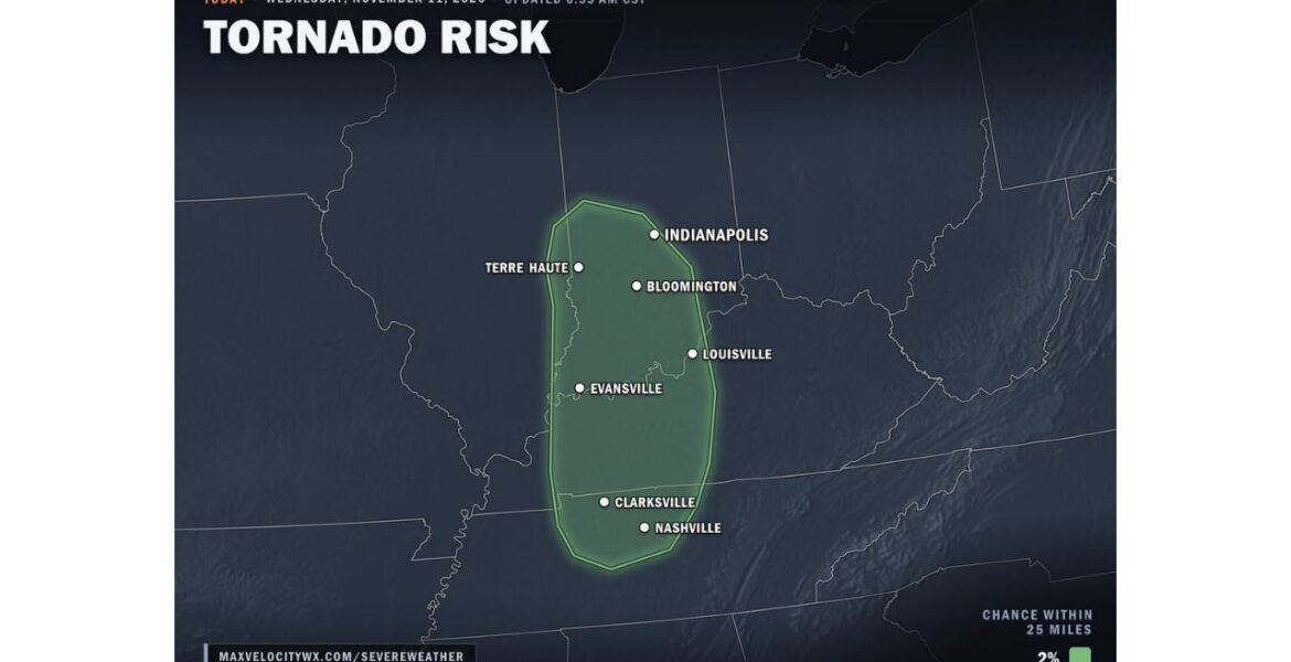
LOUISVILLE, Kentucky — A brief tornado cannot be ruled out on Wednesday afternoon and evening November 11 across Indiana, Kentucky and Middle Tennessee. Our tornado risk map, updated at 6:55 AM CST, outlines a zone that includes the Indianapolis, Louisville and Nashville areas. The chance is low, at 2% within 25 miles of any point in the zone, but it is enough for residents to stay alert.
What a 2% Chance Within 25 Miles Really Means
A 2% tornado chance may sound tiny, and it is. It means there is about a 2 in 100 chance of a tornado touching down within 25 miles of any location inside the outlined area. Most people in the zone will not see a tornado on Wednesday.
Still, for mid-November, any tornado risk is worth paying attention to. Storms this time of year can move fast and form quickly, often giving people less time to react.
Seven Cities Inside the Risk Zone
The outlined area runs north to south across three states:
- Indianapolis sits near the northern tip of the risk zone in central Indiana.
- Terre Haute sits along the western edge in west-central Indiana.
- Bloomington falls near the middle of the Indiana portion of the zone.
- Louisville sits along the eastern edge, right on the Indiana and Kentucky border.
- Evansville sits in the southwest corner of Indiana, near the center of the zone.
- Clarksville sits just across the Kentucky line in northern Tennessee.
- Nashville sits near the southern end of the zone in Middle Tennessee.
Western Kentucky between Evansville and Clarksville is also fully inside the risk area.
Why Middle Tennessee Is Part of the Picture
The storm system moving through the Ohio Valley is dragging a cold front across the region. Ahead of that front, warm and moist air is pushing north from the South. That warm, humid air stretches farther south than the main storm activity, reaching into Middle Tennessee.
When warm air at the surface meets changing winds higher up, storms can begin to rotate. That is the setup that brings a small tornado chance all the way from Indiana to Nashville.
Afternoon and Evening Is the Window
The tornado risk is focused on Wednesday afternoon and evening, when daytime warming gives storms their best chance to strengthen. Storms are expected to move from west to east across the zone. Communities farther west, like Terre Haute and Evansville, could see storms first, followed by Louisville and Nashville later in the day.
Along with the small tornado chance, the strongest storms could also bring gusty winds and hail.
Brief Tornadoes Can Spin Up Fast
The type of tornado expected is a brief one. These usually form quickly, stay on the ground for only a few minutes and are often weaker. But even a short-lived tornado can damage roofs, snap trees and knock down power lines.
Because they form so fast, warnings may come with only a few minutes of lead time. That is why it helps to know your plan before storms arrive.
Getting Ready Before Storms Arrive
- Pick your safe place now, such as a basement or an interior room on the lowest floor away from windows.
- Charge your phone and make sure emergency alerts are turned on.
- Keep shoes, a flashlight and a helmet near your safe place.
- Leave mobile homes for a sturdier building if a Tornado Warning is issued.
- Bring pets inside before storms reach your area.
- Check the radar during the afternoon and evening, especially in Indianapolis, Louisville and Nashville.
Boxingessential.com will continue tracking the tornado risk across Indiana, Kentucky and Tennessee, including Indianapolis, Louisville, Evansville and Nashville, and will provide updates as storm timing, warnings and damage reports develop through Wednesday evening.
You may also like
Leave a Reply