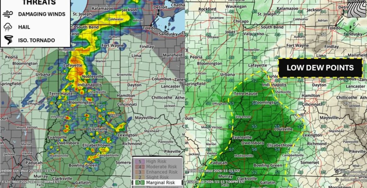
BLOOMINGTON, Indiana — A few strong to severe thunderstorms are expected to fire up across parts of eastern Illinois, Indiana, Kentucky and Tennessee on Wednesday November 11. The area sits under a Marginal Risk, Level 1 of 5, with storms possible after 4:00 to 5:00 PM ET. There is one big factor working against stronger storms tonight, and it comes down to how much moisture is in the air.
Three Threats on the Table
Even with a low overall risk, the strongest storms could bring:
- Locally strong to damaging wind gusts that can snap tree limbs and knock out power.
- Hail, mainly in the stronger storm cores.
- An isolated tornado, though the chance is low.
Widespread severe weather is not expected. Instead, a handful of storms could briefly turn strong as they move through.
Forecast Radar Shows a Line Through Central Indiana and Kentucky
Our forecast radar for 7:00 PM EST shows a line of storms stretching from northern Indiana down into central Kentucky. Storms are shown near Lafayette, Noblesville and Indianapolis, then continuing south past Terre Haute and Bloomington.
Farther south, scattered storms are shown around Louisville, Elizabethtown, Campbellsville and Bowling Green. A separate band of rain stretches north toward South Bend and Fort Wayne, along with parts of southern Michigan.
Late Afternoon Through Late Evening Is Prime Time
- 4:00 to 5:00 PM ET: The first strong storms become possible as the afternoon warms.
- Early evening: Storms organize into a line across central Indiana and Kentucky.
- 7:00 PM EST: The line stretches from Indianapolis to Bowling Green on our forecast radar.
- Late evening: Storms push east, and the threat slowly fades overnight.
Dry Air Puts a Lid on This Event
The main reason this storm risk stays limited is a lack of moisture near the ground. Storms feed on warm, humid air. When that moisture is lacking, storms have less fuel and struggle to grow strong.
Forecasters measure this moisture using the dew point, which shows how much water vapor is in the air. Higher dew points mean muggier air and more storm fuel. On Wednesday, dew points are only expected to reach the low to mid-50s in the risk area, which should keep the atmosphere from becoming overly unstable.
A Sharp Moisture Divide Across the Region
Our dew point map for 7:00 PM EST shows the moisture is mostly confined to a narrow area:
| Area | Dew Points |
|---|---|
| Louisville and southern Indiana | Around 55 |
| Western Kentucky and areas near Evansville | Mid-50s |
| Chicago and northern Indiana | Around 43 |
| Western Ohio near Dayton and Columbus | 30s to 40s |
That means storms moving east into drier air near Cincinnati, Dayton and Lexington are likely to weaken.
Why Even a Low Risk Matters
A Level 1 risk is the lowest severe category, but it still means a storm or two could cause damage. Wind gusts are the most likely issue, and they can bring down branches onto roads, cars and power lines. Fast-moving evening storms can also catch people off guard during the commute or while outdoors.
How to Stay Weather Aware Tonight
- Keep alerts turned on from late afternoon through late evening.
- Head indoors as soon as you hear thunder or see lightning.
- Move vehicles under cover if hail is reported nearby.
- Secure outdoor furniture and trash cans before storms arrive.
- Know your safe spot, such as an interior room on the lowest floor, in case a Tornado Warning is issued.
Boxingessential.com will continue tracking strong to severe storms across Illinois, Indiana, Kentucky and Tennessee, including Indianapolis, Bloomington, Louisville and Bowling Green, and will provide updates as storm timing, warnings and wind reports develop tonight.
You may also like
Leave a Reply