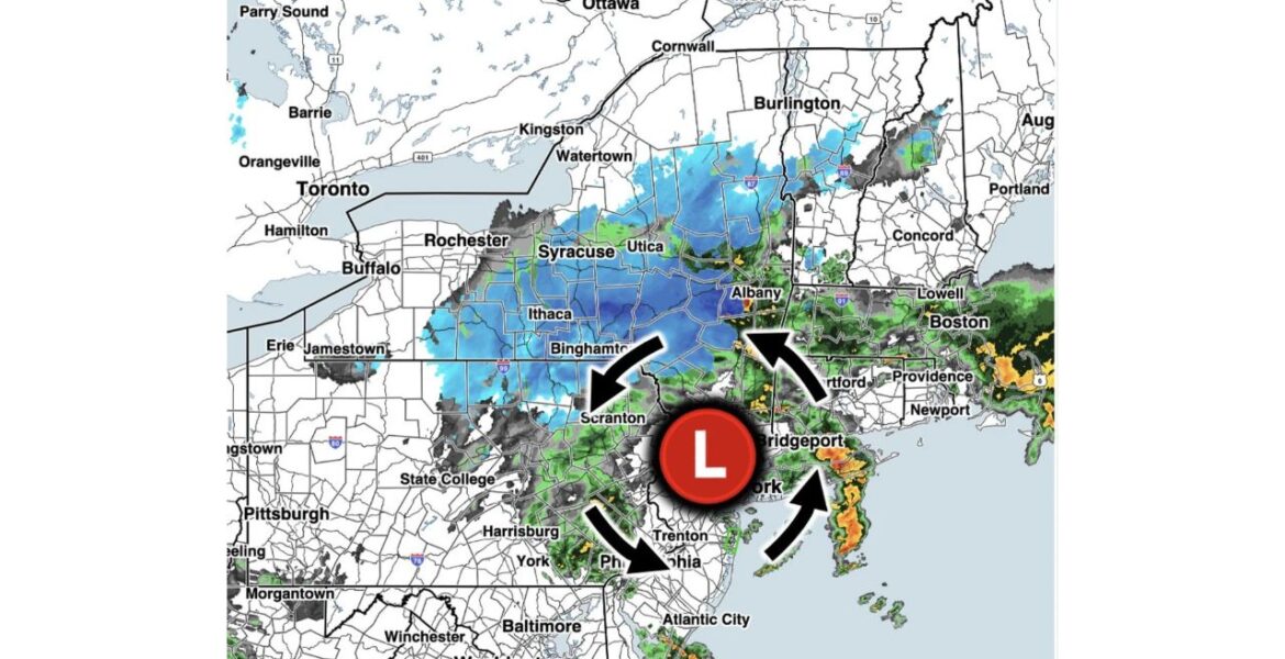
ALBANY, New York — The first snowfall of the season arrived across the Northeast on Thursday evening November 12. Radar at 9:50 PM EST showed snow spreading across upstate New York and northern Pennsylvania on the back side of a strengthening storm. Snowfall rates of 1 inch per hour or more were possible through the overnight hours, setting up a wintry start to Friday morning.
Snow Wraps Around the Back of the Storm
The storm’s center sat near New York City and northern New Jersey on Thursday night, with winds spinning counterclockwise around it. On the storm’s back side, those winds pulled colder air down from the north into New York and Pennsylvania. That cold air was just enough to turn rain into snow.
On the storm’s front side, warmer air from the ocean kept precipitation falling as rain along the coast. That created a sharp divide between snow inland and rain near the shore.
Upstate New York Turns White
Snow covered a wide area on radar, stretching across much of upstate New York:
- Jamestown and areas near Lake Erie saw snow on the western edge of the storm.
- Rochester, Syracuse and Utica were inside the snow shield.
- Ithaca and Binghamton sat under a broad area of steady snow.
- Albany was near some of the heaviest snow bands, shown in darker blue on radar.
- Northern Pennsylvania saw snow reaching close to Scranton.
Snow also showed up in parts of Vermont and New Hampshire, especially in the higher terrain.
Heaviest Bands Near Albany
The darkest blue colors on radar sat between Binghamton and Albany, where snow was falling hardest. In these bands, snowfall rates of 1 inch per hour or more can quickly cover roads, cars and grass. Higher elevations in the area were most likely to see snow pile up fastest.
Rain Line From Scranton to Hartford
Just south and east of the snow, the storm brought a cold, steady rain. The rain and snow line ran roughly from near Scranton toward Albany and Hartford. Cities south of that line stayed mostly rain:
| Area | Precipitation on Radar at 9:50 PM EST |
|---|---|
| Syracuse, Utica, Binghamton | Snow |
| Albany | Heavier snow bands nearby |
| Scranton, Harrisburg, State College | Rain with some mix nearby |
| Philadelphia, Trenton | Rain |
| Hartford, Providence, Boston | Rain |
| Bridgeport and Long Island | Heavy rain |
Downpours Pound the Coast
The heaviest rain on radar fell near Bridgeport and across Long Island, where orange and red colors showed intense downpours. More heavy rain bands moved toward Boston, Providence and Newport. Gusty winds near the coast added to the messy conditions.
Why This Snow Matters
This snow marks a big change after one of the warmest falls on record across much of the country. For many people in upstate New York, it is the first time this season they have had to clear snow from their cars. Early snow can also catch drivers off guard, since many have not yet adjusted to winter driving.
Friday Morning Commute in Upstate New York
With snow falling overnight, roads in Syracuse, Utica, Binghamton and Albany could be slick by Friday morning. Bridges, overpasses and hilly roads are usually the first to turn icy. Plow crews may still be working to clear roads early in the day.
Tips for Driving in the First Snow
- Clear all snow and ice from your car, including the roof, lights and mirrors.
- Drive slower than usual and leave extra space between cars.
- Brake gently and avoid sudden turns on snow-covered roads.
- Watch for black ice on bridges and shaded areas.
- Keep a winter kit in your car with a scraper, blanket and snacks.
- Check road conditions before heading out on Friday morning.
Boxingessential.com will continue tracking the first snow of the season across New York, Pennsylvania and New England, including Syracuse, Binghamton, Albany and Boston, and will provide updates as snowfall totals, rain and road conditions develop.
You may also like
Leave a Reply